Seems
impossible that tens of thousands of structures could lie hidden within an
800-square-mile piece of real estate for more than a millennia, so imagine the astonishment in the archaeological community when LiDAR
(“Light Detection And Ranging”) technology made that actually happen. Millions
of laser pulses shoot from the air and bounce off hard surfaces on the ground
to produce a three-dimensional view without vegetation concealing man-made
features. This technology has revolutionized the world of archeology.
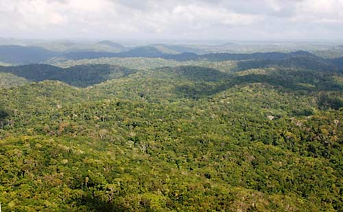
The El Petén covers
13,843 square miles, most of it blanketed beneath a thick jungle canopy.
Before
2018, about 100 ancient Maya sites had been identified in this region,
most
still obscured by dense rainforest.
In
2018 a LiDAR project was initiated by PACUNAM, a Guatemalan nonprofit that fosters
scientific research, sustainable development and cultural heritage preservation.
Selecting portions of the Petén region of northern Guatemala, southern Mexico
and western Belize – known location for hundreds of ancient Maya cities
– the 3D laser map stripped away the canopy to reveal more than 60,000 previously
unknown buildings, walls, ceremonial caves and road systems.
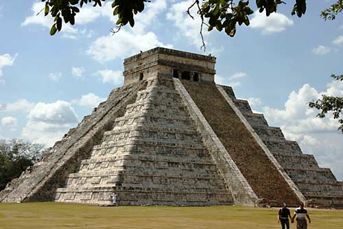
The Pyramid of Kukulkán
is recognizable world-wide as the symbol of Chichén Itzá
and the Maya’s prowess
with celestial alignments, yet few realize only a small
portion
of the
buildings at this Unesco World Heritage Site have been explored
and hundreds
more await excavation.
Less
than 150 years ago the Maya civilization was a total mystery. Heck, 200 years
ago the very possibility of such a culture to have arisen in the Americas, let
alone flourished, was considered impossible. When evidence of their achievements came to light, no one believed an
indigenous culture could have developed such wisdom without outside influence.
Areas of particular note include astronomy (knowledge of the Milky Way’s Black
Hole, procession of the equinoxes, cycle of Venus, solar and lunar eclipse predictions),
architecture (the corbel arch, many times more pyramids than the Egyptians), mathematics
(possibly the first in the world to conceive of the concept of “zero”), calendar
(theirs was as accurate as our modern version), and language (one of only five
civilizations in the world to develop a written language).
Even
30+ years ago, refer to the “Maya” and most folks were clueless, at least until
the “Maya Doomsday Prophecy” of Dec. 21, 2012 took the world by storm. Many
recent television specials and series have aired about them but when did the
discovery of marvelous civilization actually begin?
THE EARLY
EXPLORERS
Among the first and arguably the most prolific of early Central
American explorers were John Lloyd Stevens, a lawyer, diplomat, explorer and
writer from America, and Frederick Catherwood, an architect and artist from
England. Hearing rumors of an ancient civilization in the Americas, Stevens and
Catherwood spent 1839 and 1840 uncovering, surveying and recording nearly four dozen sites across today’s Honduras, Guatemala and
Yucatán Peninsula. Catherwood’s use of a camera Lucida to assist in his drawings
produced wonderful images of intricately carved stela (freestanding monolithic
stone monuments) and beautifully decorated buildings.
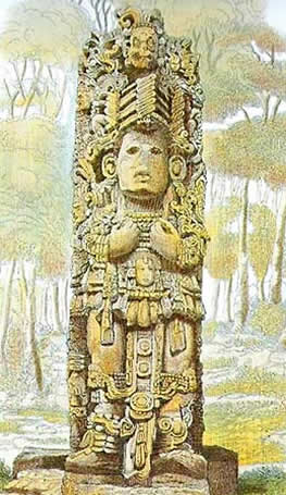
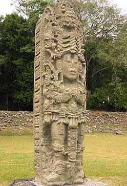
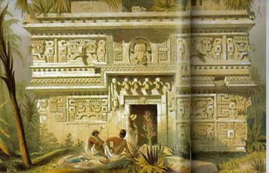
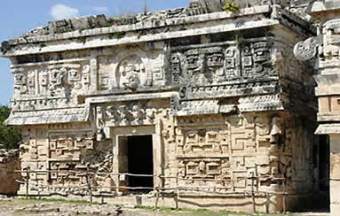
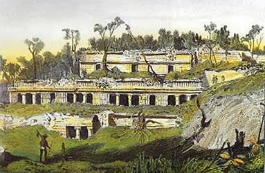
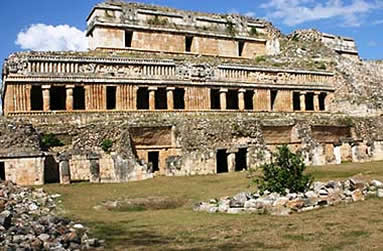
Three of Frederick Catherwood’s renderings compared to what can be seen today:
Copán’s elaborately-carved Stela A, the ornate 50-foot-tall Nunnery at Chichén
Itzá, and Sayil’s massive 90-bedroom Grand Palace.
(Catherwood’s images from “The Lost Cities of the Mayas: The life, art
and discoveries of Frederick Catherwood”)
Stevens
published two books about their discoveries including more than 200 of
Catherwood’s drawings: 1841’s Incidents
of Travel in Central America, which sold more than 20,000 copies in the
first three months, and 1843’s Incidents
of Travel in the Yucatán. Catherwood’s own 1844
publication, Views of Ancient Monuments
in Central America, Chiapas and Yucatán, featured hand-colored panels. The
world was stunned, and puzzled.
In
the latter 19th and early 20th centuries, trained
archaeologists, engineers and architects including American Sylvanus Morley,
German Teobert Maler, and Englishman Alfred Maudslay spent years furthering the
discovery, excavation and recording of ancient Maya sites across the region.
Sadly,
their methods were not always the best even under the “guidance” of
institutions that should have known better. Carnegie Institute-sponsored
archaeologists used dynamite in attempts to locate tombs at Uaxactún, also a
tool of choice for late 19th/early 20th century
excavations at Xunantunich. Part of the façade on Chichén Itzá’s Nunnery was
blasted away by a 19th century explorer. Kerosene was used to clean
the murals at Bonampak.
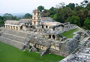
Palenque’s massive
Palace complex was the victim of horrific carnage during Del Rio’s search
for
valuables and souvenirs. Among other damage and theft, he chopped off a head
and leg
from figures on a stucco pier lining the façade of the Palace.
A
century earlier, in 1786, the Palace at Palenque was the focus of unbelievable
damage when Captain Antonia Del Rio searched for treasure. He hired 79 local
Maya, equipped them with axes and billhooks, set fire to this enormous complex
to allow easier access, then hacked away pieces to send back to his monarch in Spain
as proof of the ancient city they had plundered. To quote from Del Río’s
report, "Ultimately there remained neither a window nor a doorway blocked
up; a partition that was not thrown down, nor a room, corridor, court, tower,
nor subterranean passage in which excavations were not effected from two to
three yards in depth, for such was the object of my mission."
To
add further insult, his report was lost in the Spanish archives. Just a year
prior another group had made the first real examination of the site and sent
their findings to Antigua, Guatemala, seat of Spanish colonial government in
Central America. Where it was lost in the Royal Archives for a hundred years.
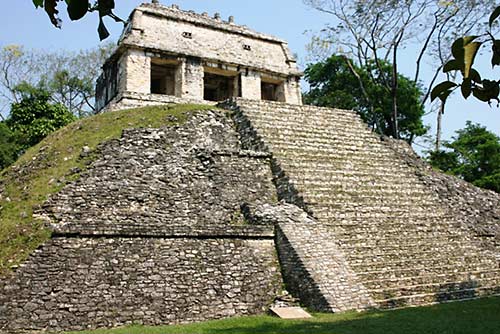
During his 1831-32 visit to Palenque, Count Frederick Waldeck set up residence
in the temple atop this pyramid, resulting in its moniker
“Temple of the Count.”
One of the first
Westerners to document the site, he didn’t do any damage
but his sketches incorporated
a lot of imagination, to put it politely.
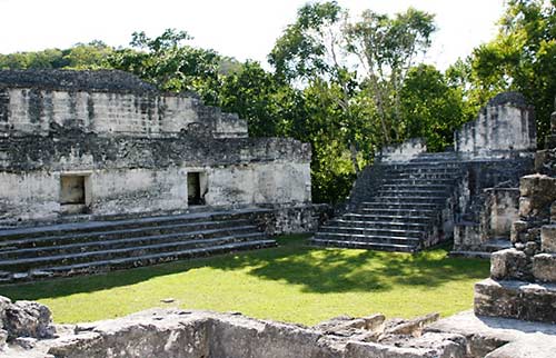
Teobert Maler hung his Mi Casa sign in Structure 5D-65 of
Tikal’s Central Acropolis,
an immense complex stretching nearly 700 feet long
across four acres.
Maler’s abode during his 1895 and 1904 visits dominates
Court 2
and is commonly referred to as “Maler’s Palace”.
Imagine
actually living inside one of these 1,000-plus-year-old structures while
spending the day excavating a long-lost city.
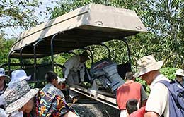
GETTING THERE IS HALF THE
ADVENTURE
Early
visitors had to go by horseback, trek for days over and through unforgiving
terrain, or take on wild rivers. Today’s choices are
much less challenging but can still be an adventure in itself, even on what
seems should be an easy drive on established routes.
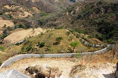
Perched atop a plateau
surrounded by deep ravines in the Motagua River Valley of Guatemala,
the road
to Mixco Viejo twists and snakes it way up the high ridge,
and feels like the
tail end
of a cattle call on the way to Ceibal in Guatemala’s Petén region.
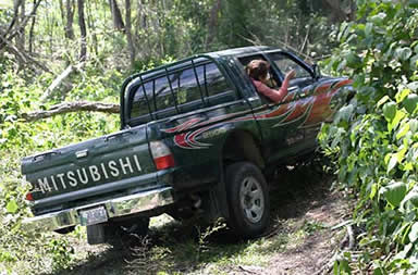 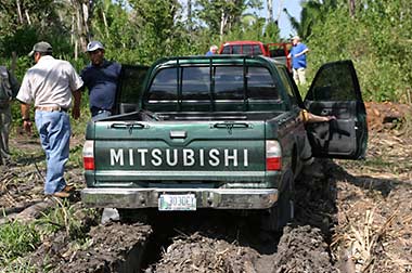
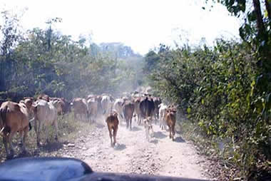
“Sure, we can fit!”
Venturing into the less-traveled regions of the Petén, our drivers knew the
route to Naranjo but the prolific jungle vegetation made clearance and choice
of path sometimes questionable. Taking a different route upon our departure
proved equally challenging, expending about an hour and one tow chain.
Or it can be as simple
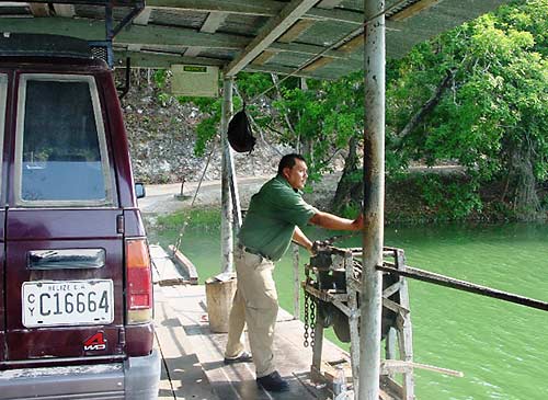
as driving onto the hand-cranked ferry across the Mopan River
to reach
Xunantunich, near the Belize-Guatemala border.
Built on a limestone ridge
above
the river, the site enjoys a panoramic view of the upper Belize River Valley
and across a huge swath of Guatemala.
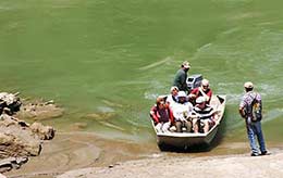
So
if you have to cross a river, why not just start with a boat? Zipping up foliage-festooned
waterways and spotting wildlife is a huge perk. Other than the hum of an
outboard motor, you might think you were joining some early voyager checking
out rumors of long-lost cities in the rainforest.
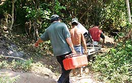
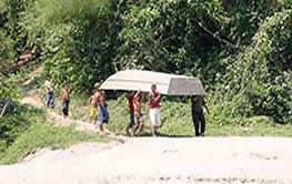
Normally the boat is in
the water and ready to go, but in the case of Piedras Negras you transport your
watercraft to the launch site on the Usumacinta River and schlep boat and motor
to the water,
hopefully with some able-bodied assistance.
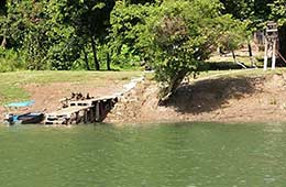
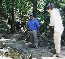
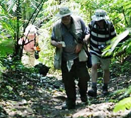
You
might pull up to a dock and saunter into the site, or there may be some stairs
to ascend. Or you may be confronted with an uphill climb that never seems to
end…do not forget your trekking staff.
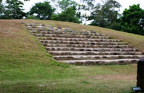
Ceibal is accessible via
two routes – a sometimes cattle-clogged road (see above) or up the Río la Pasión.
The only drawback to the river
route is a rocky hike into the site beneath the towering ceiba trees
which gave the site its name. And then there’s
Aguateca and the 200 very steep steps up the
300-foot-tall ridge from its landing
site on the Río la Pasión.
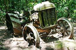
Ascent from the landing
spot on the Usumacinta River to the site of Piedras Negras entails an hour’s
uphill hike into one of the most remote parts of Guatemala. As if to tease, near
the top is an abandoned Fordson tractor left by the University of Pennsylvania 1930's
expedition.
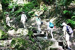
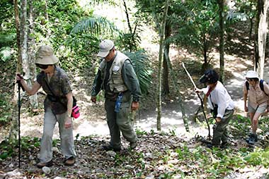
Even once you reach a
site, exploring some of the structures may take a bit of huffing-and-puffing. Naranjo’s
Central Acropolis, cleared enough to ascend, still awaits
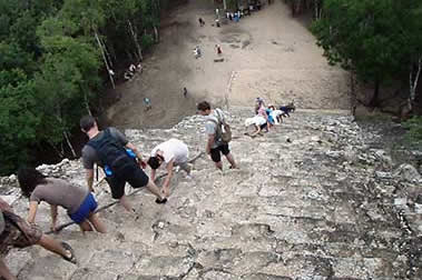
excavation. The 138-foot climb up Cobá’s
Nohoch Mul pyramid, with a wire cable
assist, rewards with a panorama of the surrounding jungle
punctuated by three
small lakes.
| |
 |
|
 |
|
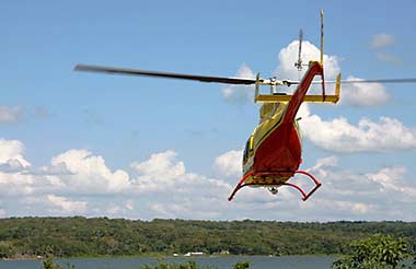
A whirly-bird is the
easiest way to access El Mirador, which is about an hour’s flight north of
Flores in the Petén, versus a two-day journey on horseback. Easiest way to see
the five main but sprawling (about a 5-mile walk) groups of structures at Cobá is
by bicycle or pedi-cab, both available for rent at the entrance, with easy
pedaling along the raised roadways criss-crossing Cobá. Often 10-15 feet wide
and elevated a couple of feet, these sacbé (pl. sacbeob) connected ancient Maya cities and some are so massive they have been
seen from space. Cobá itself is the hub of a nearly 100-mile network, one road
plunging in a nearly straight line for 62 miles through the Yucatán forest to a
city near Chichén Itzá.
Here is a much easier way to get to some of Mexico's historic sites, via a two-week tour that includes cities and beaches with Bookmundi's Mexico Unplugged.
WHAT’S THERE
TO SEE?
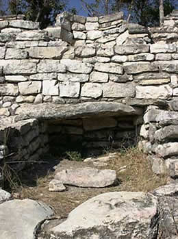
Pyramids
are often associated with tombs and it’s no different with the Maya, although
not all pyramids contained tombs nor were all tombs placed inside pyramids or
temples.
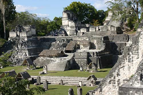
It is estimated that
70% of Tikal’s temples were burial monuments.
The North Acropolis is a
collection of nearly 100 buildings
sprawling across a 2.5
acre base. Built over many earlier versions,
one includes eight funerary
temples constructed a millennia-and-a-half ago.
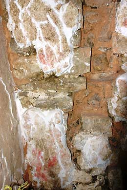
Caracol’s 140-foot
Caana, tallest building in Belize, has three respectably-sized pyramids adorning its summit but not visible from ground level. The tallest of
these held the ornate burial of a woman, and remnants of red paint on the back
wall above her tomb can still be seen (above
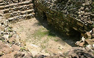
left). The large pyramidal Structure 42 at Tenám Puente included several
burials, some in niches built of rubble (above
right), others in circular graves,
and those whose cremated remains were
placed in clay pots.
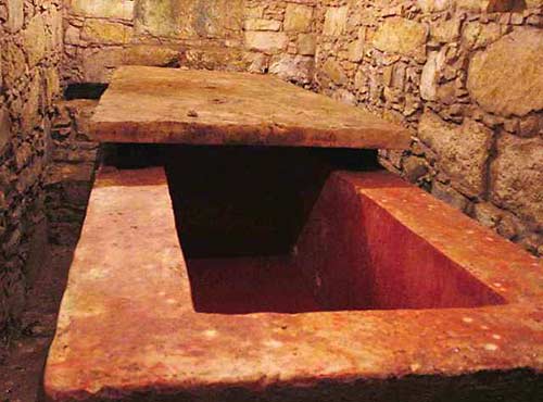
The Temple of the Red
Queen contained the second-richest burial at Palenque, exceeded only by Pakal,
even though early looters removed much of the offerings. Everything inside the
tomb was covered
in a heavy layer of cinnabar (mercury sulfide), which to the
Maya represented death and rebirth.
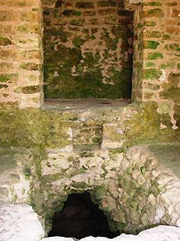
Some tombs are so modest
they were overlooked for decades. In 2012 at Takalik Abaj,
excavation of a
16-foot tall grassy platform such as this one (Structure 11)
revealed the
2,500-year-old tomb of the Vulture Lord beneath
an eight-foot mound of clay and
cobblestones.
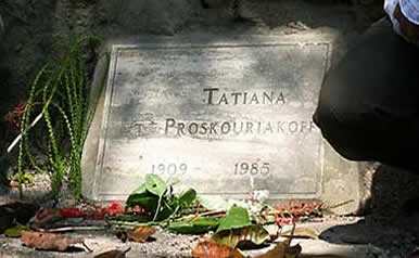
Piedras Negras burials include
the affluent tomb of the third ruler who died in 729 CE, as well as Tatiana
Proskouriakoff who is credited with “cracking the Maya code” and deciphering
the intricacies of Maya politics. Although she died in 1985, her ashes couldn’t
be interred in the West Acropolis until 1998 when Marxist guerrillas using the
area during Guatemala’s civil war cleared out.
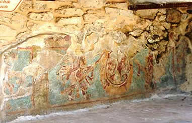
Ancient
Maya cities were a stunning site with their white-plastered plazas surrounded
by brightly painted buildings, many of which still carry traces of reds, blues
and other hues. Murals, painted walls and carved friezes still convey the artistic
skill of these skilled artisans.
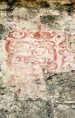
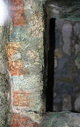
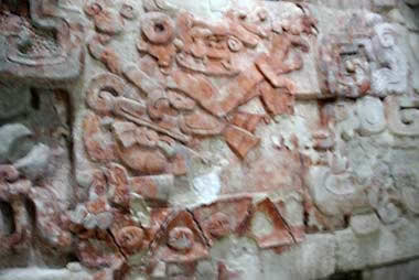
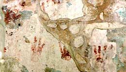
Near the doorway of
Structure II at Chicanná, red glyphs painted on an earlier layer
were revealed
when an over-layer of stucco fell off (above
left).
Huge sculptures of kings and gods adorned the walls of Cancuén’s
Palace (above right).
Colorful doorways and
walls are still evident on the Temple of the Bats
and Structure 25 “Las Manitas”
in San Gervasio on the island of Cozumel.
Murals are found across
the Maya region including Yaxchilán’s Structure 33 (above left)
and Mayapán’s Room of the Frescos (above right).
Earlier, more elaborate
and history-breaking examples
are being discovered all the time.
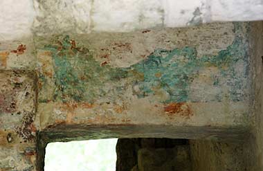
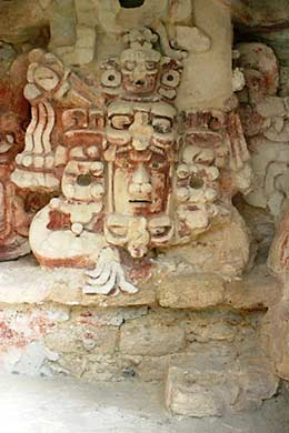
Applying a thick layer
of stucco, the Maya carved facades and friezes of their gods and mythology.
Structure XIII at Becán contains a massive façade (above left) protected by a pane of glass.
At nearby Balamkú, an
earlier construction under Structure I, “House of the Four Kings,” was
decorated
with a 55-foot-long, nearly 6-foot-tall frieze of the Maya cosmology, traces of original paint are still evident.
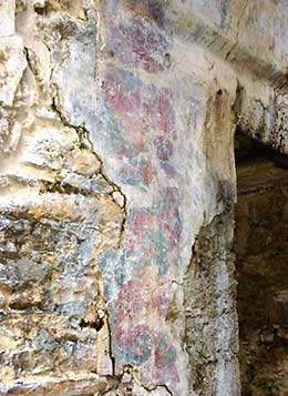
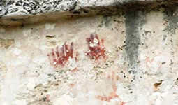
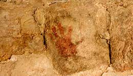
The significance of red
handprints isn’t certain, perhaps a reference to the Maya god Itzamná who was
also called Kabul, “divine or
celestial hand.” Examples are found in the Temple of the Frescos at Tulúm (above left), the main corbel vaulted
entry to the Nunnery at the Unesco World Heritage Site of Uxmal (center), and in Structure 25, “ Little
Hands” (named for the handprints) at San Gervasio.
There
isn’t much opportunity for regular folks of ordinary means and physical ability
to experience an Indiana-Jones-type adventure, but visiting ancient Maya cities
comes pretty darn close. While amazing, colossal structures can overshadow details
like tombs, murals and larger-than-life-size carved façades, there is a mystery
to walking the paths, climbing the stairs, and peering into rooms inhabited a
thousand or more years ago.
This
journey of discovery isn’t over - in next issue’s Part 2 we’ll look at some
current excavation projects, some major discoveries, and the havoc wrought by
looters and, sadly, the Catholic Church.
Other
Maya-related articles by Vicki Hoefling Andersen:
Belize: The
Western Frontier
Belize: The
Eastern Edge
Lords of the Petén, Guatemala
Life Along the
Rio La Pasión
Highlands of Guatemala
Palenque, Mexico
Chiapas, Mexico
Abandoned
Cities of Chiapas, Mexico
Ancient Cities
of the Rio Bec
Ancient Cities of the Río Bec
Part 2
Roaming
Mexico’s Yucatán Peninsula
Isla Mujeres:
Island of Women
The Maya &
2012: A New Beginning
|